On the Top of a Unified Expert System (↕)
by ****/ alias X. Webermeister [1]
=======================================================================================
– Entwurf aus der Website zum »Unterfangen Weltpuzzle«® -- https://kognik.de
Online-Zugang: Home; Sitemap; Dateien-Übersicht; Glossar; Tipps & FAQs
Offline-Version: Home; Sitemap; Dateien-Übersicht; Glossar; Tipps & FAQs
Home
--> Puzzle WELT --> Abbildungsseitiges --> Der LEGE-Raum --> Abstraktionskegel_Charakter
--> Dimensionalität --> Aufspannung
zitierbar als:
https://kognik.de/ONLINE/veroeffentlichungen/paste8/paste8.doc
--------------------------------------------------------------------------------------------------------------------------
Stand: Versions-Nummer = 0,8 / 1,1 {– Hier sind die Errata der Original-Veröffentlichung bereits eingearbeitet.}
Wortfeld: Unifizierung; Expertensystem; Diskurs- + LEGE-Raum; dessen Aufspannung; Unifizierung, Paradebeispiele; „Universalie“ (↑) versus: „Spezialbelang“ (↓) ; Kognitive Ökonomie; Verschränktheit; Selbstähnlichkeit; ...; ...; …
Vgl. aus der lokalen kognitiven Nachbarschaft: \Weltmach – Kapitel 1; \Prinzipgrafik: „Zentraler Hub“ – in Draufsicht; \zur „Methodenflanke des »Referenzideals der Abbildung der WELT«; \„Fraktale Dimensionen“ der LÖSUNG; \„Verschränktheit im / des Kognischen Raums‘; \Die gesamte Palette der ‚Zoomphänomene‘; \...; \...
=======================================================================================
1. Geography – Reverse Engineered
Imagine taking off in a spacecraft and, throughout your trip, watching the ground below you through a camera. Observe how the knowledge content on the screen gradually changes: take-off ramp; bird`s-eye view; fence enclosing the site; nearest roads; panorama of settlements; coast of continent; etc :
On your way take notice of four basic phenomena (Box #1). We will catch them up again and again in this paper.
Box #1: Phenomena in Cognitive Zooming
1. An immense wealth of new information keeps migrating into the field of view from off screen.
2. Any feature that catches your eye moves, under progressive reduction, towards the screen's center and, there, finally seems to disappear due to the limit of vision acuity.
3. Complexity
should increase tremendously due to this immense stream of heterogeneous data.
But a mental process of clustering keeps building up larger structures
instead:
buildings; blocks; towns; woods; mountain areas; river systems;
etc.
These intermediate structures, too, will be blurred out with the distance of
the spacecraft further increasing.
4. This photographic scenario reproduces nothing but visible knowables. It gains all its knowledge directly from their source. It reflects reality on the ground just as it is there. This technical process works independent of man, too; it thus operates completely unbiased by human expectation §is unbiased by any – dubious – modeling!§.
Remark
that at a certain moment this process, instead of continuing smoothly, suddenly
changes character. As before detail continues to disappear towards the center.
But now, no further information is entering any more from off screen: the
earth's horizon has just come into the field of view. Beyond it, nothing but
"empty" space. The flat-ground impression of the observation turns
out to have been created by something different: Before us lies the surface
of an immense globe – moving in space.
Our original impression did, by no means, originate from an infinite plain nor from
a disk as humanity once liked to imagine.
Let's interrupt our trip at this critical point. For the purpose of this paper I would like to rename its scenario as: »Generating the Abstraction Cone of Geographical Knowledge«. Its operation of zooming upwards started from a very local `human scope', crossed several orders of magnitude, until the `space perspective' had, finally, been reached.
Transfering this operation of abstraction to other fields of knowledge and investigation of its architectural principles will be the subject of this paper.
I would, first, like to draw the attention to five features of invariance of this specific kind of operation:
Box #2: Invariances
1. No matter at which spot or country we chose to start our zooming trip, the final result visible will always be the same – the one and unique globe of the earth.
2. No matter whether we make the zoom start from a view through a microscope; a bee hive; from a picnic party; from some vista point; no matter whether it is simulated by pictures or maps, despite all the diversity of content visible at the departure point, the result at the end of zooming will always be the same.
3. Done 5000 years ago, today or in 5000 years time, the final result will hardly change.
4. Even
if information may be hidden by clouds, darkness or discrimination limits due
to grain size, none of the observable objects physically disappears. Even the
start ramp, by now long forgotten, has never moved. It will reappear whenever we
zoom back again to its position and time.
Latently it continues to exist as a
»knowable«.
5. No matter how many local details may be unknown to us ("never been to the Himalayas"), partial weaknesses within our knowledge base on far away areas progressively migrating into view, does not, in any way, impede reaching the full and faultless perspective: The GLOBE itself.
On the GLOBE, points of interest and, thus, potential
starting points for this abstraction process are overwhelming in number and
complexity. Out of sheer necessity mankind, therefore, had to build a kind of
an expert system. In doing so, man once had to agree on the science for its description:
“Geography”. But in the beginning, based on local horizons only, it even turned
out to be difficult to provide for it an overall system of orientation.
It was only when introducing a daringly-abstract view
point – “The Space Perspective” – that some natural frame of reference became
evident. A huge globe built of somewhat heterogeneous matter:
A geometrical origin right in its center + three orthogonal coordinate
directions emerging and a surface at a radius of about 6400 km. Of
the three directions only one had to be man-made (“Greenwich”). The other two could
not be missed after first notifying the overall rotation of this globe.
Obviously it would be most uneconomic to modify this coordinate system, e. g. by basing the description on only one or on more than three geometrical coordinate axes instead. Or to displace the origin from the center even by a hundredth of the earth's diameter. From local perspectives only, e. g. when considering "Rome / … as the hub of the world", such a convincing consensus on the frame of reference for our Geographical Expert System could never have been achieved.
Complementing the geometrical coordinate axes for the beginning by two further orthogonal directions – “Time” (allowing for rules of movement and features of evolution) and the “Periodical System of Elements” (needed for spanning and explaining the scenes of chemistry, including biology and, ultimately, mankind and its artifacts) – the top of the Geographic Abstraction Cone gets its simple, rather unique architecture.
2. Challenge in an Unified Expert System
In modern life, man has to find his way through a similar flood of knowledge. Private and business spheres become more and more dependent on technological, scientific and political issues and rules. New facts and guesses keep streaming in, e. g. via the media.
Each "local" puzzle stone of information may be used as a starting point for any kind of abstraction procedures. In learning, planning or strategic decision making, man has to deal with both, extremely detailed and highly compact information. A vast number of disciplines, state-of-the-art facts, biased opinions and gaps in knowledge of various kinds are involved. Man's generic horror of too high a complexity generates many a subjective distortion: His cognitive capacity with its limited channel width forces him to select, simplify his input or to tediously reconfigurate his personal knowledge base. One-sided methods and knowledge projections may enhance the inconsistency of an already patchy world picture. All his knowledge processing is generated or controlled on "local views" of personal experience and biased by rules and filters established during education. Inevitably this must create insecurity and misunderstanding, reasons for many a friction within human societies.
In this stress situation a "friendly" expert system could, therefore, be envisaged, too. It would have to operate for the same reasons for which the GLOBE concept is accepted as common and useful and for which it only marginally prejudices the world picture.[2]
As in Geography, a convincing perspective, i.e. a well defined frame of reference, would have to be established for such an endeavor. A major requirement is that it must be capable of structuring knowledge and drastically reducing the complexity index with a bias hopefully as low as that of a modern atlas.
This paper deals with fundamental issues of architecture and integrity of such a rather visionary expert system. It, therefore, will be dealing with basic degrees of freedom of all thinking, with data structures to reflect the "knowable" of all kinds, with steps towards grand unification, with operators and invariance’s. It is plain methodology.
Essential in doing so is the following approach: In order not to re-invent the wheel and not to be caught in the abundance of subjectivity traps mentioned above, this paper is based on the technique of Reverse Engineering. This technique is applied to time-tested solutions of integral, highly complex expert systems. Maps in geography and formulae in physics are used for illustration. This approach immediately provides for the statement of a set of scientific issues of similar scope as found in connection with the Geographical Abstraction Cone:
1. Is there, among the
infinity of ways of describing the issues of human business, a perspective of
excellence (or more than one) which covers as much structure and detail and
allows for as transparent and viable an overview as the "space
perspective" provided for in the example of the GLOBE? Is there – maybe
beyond all familiar perspectives – a common cognitive focus? This focus would
have to link heterogeneous sciences, or any sub-cones of abstraction they use for
describing their accomplishments, in a similar way the globe concept once
re-configured all knowledge and unknowns about the earth. Are there good reasons
for such a focus to exist at all? In short:
Is there, if the abstraction trip only goes far enough, something like
a canonical form? [3]
2. Which cognitive procedures
would stand for the performance provided by cameras zooming, i.e. the objective
and automatic process of having relevant knowledge migrate into view and fade
away again reliably? How many orders of magnitude would have to be passed through?
[4]
What cognitive / scientific criteria, anyway, do correspond to the permanent
"upward" movement as assumed here – in order to create such abstraction?
3. If an Abstraction Cone is found, towards the top of which all other structuring of knowledge converges, what does its architecture look like? Does the space of discourse spanned by this concept again have some kind of shape, some finite contours and metrics? How will top levels correlate with lower abstraction levels? What methods of analysis and synthesis, proof and falsification can best be relied on?
4. Human attention, seen as a mental beam sweeping through this Space of Knowledge or the Space of Planning, what do its cognitive tracks look like; what are its predilections; where are phobias; what are generic distortions in this process? How much control is left to the individual?
5. What would be the limits of validity of this concept? Any Abstraction Cone – even the “mature” GLOBE concept – covers only a restricted area in the universe. This area is defined in scope by the view point chosen i.e. the position of stopping the ground gaining abstraction trip.
Such fundamental scientific and methodological issues will have to be investigated at a later stage in all due rigor. This paper will, however, concentrate on the architecture of a specific Abstraction Cone, one which seems to come close to the one requested for the above unified expert system.
3. Formulae – Reverse Engineered
Yet, before addressing issues, which ultimately should integrate areas so dissimilar as Economics and Biology; Information Technology and Psychology; Medicine and Conflict Theory; Behavioral and Planning Science, I would like to illustrate with another classical example, what Abstraction Cones – our pathfinder concept on expert systems – might look like.
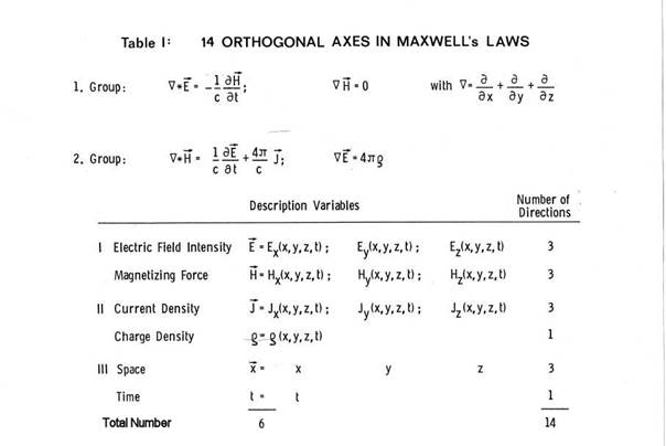
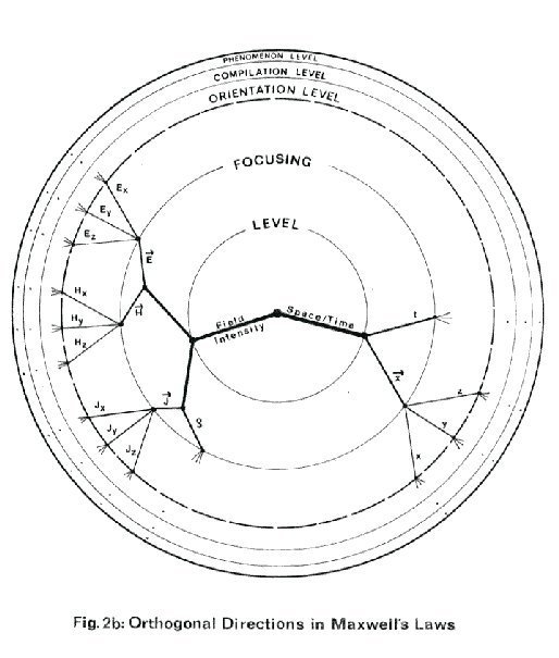
When Maxwell's laws are reverse engineered below, they stand for all similar scientific-mathematical formulae:
- They are mental make-ups to describe nature´s behavior
- They provide for an extremely compact knowledge base, virtually impossible to be described in similar precision by means of words only
- They allow the deduction
of any type of issue within their established range of validity
as soon as the issue´s boundary conditions have been specified
- They might be combined
with others into a specific tool of cognitive infrastructure:
A collection of formulae to be seen as an expert system.
Maxwell's Laws, morphologically broken down in Table I, stand at the top of an immense knowledge space. This simple set of formulae covers thousands upon thousands of local electric and magnetic "occurrences", generalized phenomena as well as technological applications. They imply all classical laws of electricity and magnetism. They contain all relevant development rules for dynamos, thus, providing for an electricity-based society. They form the base of telecommunications, television, safety systems and pacemakers. They are still fully relevant in the computer age. All this is achieved by an apparently simple knowledge base consisting of just four equations.
Within the coordinate system extracted in Table I, the two groups of Maxwell's equations express a shape in some multidimensional space of discourse. They basically describe contours which distinguish between what nature allows for and what it forbids to happen in electromagnetism.
 This second example of an expert
system emphasizes additional rules on Abstraction Cones:
This second example of an expert
system emphasizes additional rules on Abstraction Cones:
1. For non-geographical areas of knowledge, too, there are specific view points of excellence. The top-level descriptions of the associated Abstraction Cones consist of a highly invariant core. The view point chosen provides the best perspective on any outlines of the area. If some dimensions of the area turn out to be finite, this feature is emphasized. A large infrastructure of cognitive tools and specific methods might be needed for establishing consistent links between all the levels of abstraction within such an Abstraction Cone.
2. Displacing on trial this specific view point will in almost any case deteriorate the perspective. Major maladjustments (e.g. by inverting one of the signs in Maxwell's equations or adding some random terms or prematurely introducing the concept of electrical resistance) would, when taken seriously, trigger the collapse of its entire puzzle.
3. Once a "natural" perspective is found its topic area is resistant to modification. Intrinsic laws tend to crystallize on the level of the core descriptions. Thus, opportunities for scientifically establishing nature's very behavior are best at the very top. However, much research may still go on filling the lower levels of the knowledge base. But, as long as the application is not extended beyond the range of validity of the perspective (i.e. the limitations of the corresponding theory as confirmed or still to be investigated), the top itself will remain untouched. On the contrary, the very concept of Maxwell's laws even enabled the treatment of phenomena unknown before: Due to the guidance they provide, the phenomenon of Electromagnetic Waves was first predicted theoretically. And ways for experimental proof or falsification were established. Soon afterwards these hypothetical waves were discovered to be a real part of nature's truth.
4. The perspective best suited to nature's laws is frequently found on a base of knowledge which is incomplete and patchy. Over-familiarity with "local" issues might prevent clear perception, interpretation or clustering of available puzzle stones.
5. By reverse-engineering the architecture of well established Abstraction Cones, we gain guidance in building additional ones. In building new expert systems we can choose which ones of the lessons learned seem most suitable for structuring the task. Some analogies are more appropriate than others for attraction and user friendliness, as needed to achieve the success of the tool.
6. Claims for scientific rigor and freedom, when superficial, might turn out to be counterproductive. Once Maxwell's laws had been confirmed (as well as they themselves are), there is no reason for requesting all radios built to be capable of operating on a hypothetical non-Maxwell electromagnetism, too. Once a radius of 6400 km has been established for the EARTH, there is not much sense in hampering daily operation by maintaining the conceptual option of having another populated surface on a hypothetical extra shell e.g. with a 2000 km radius.
4. Description Theory and the Abstraction Cone
As was illustrated above, phenomena, issues, tools, applications, explanations and other puzzle stones of an area of knowledge tend to cluster at some time in its evolution into consistent overall pictures.
Reverse engineering conclusions might, therefore, be generalized into a Theory of Observation and Description. Goals and reconfiguration criteria might become clearer in doing so. Advanced rules of procedure might be derived. Some applications, e.g. in education, research and development or expert-system building might follow.
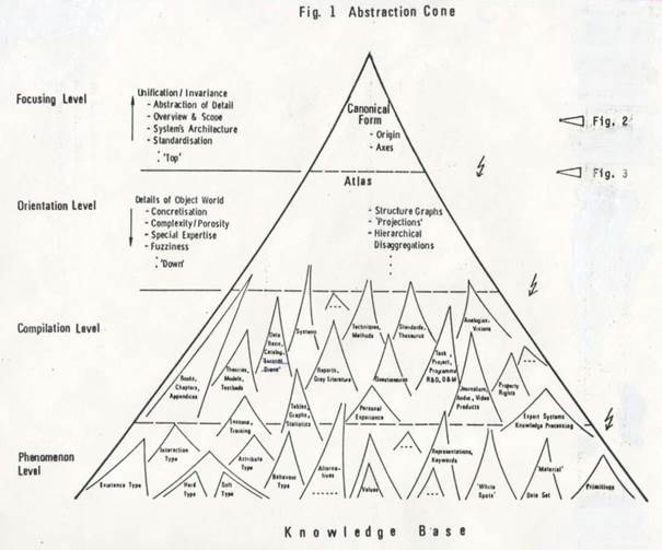
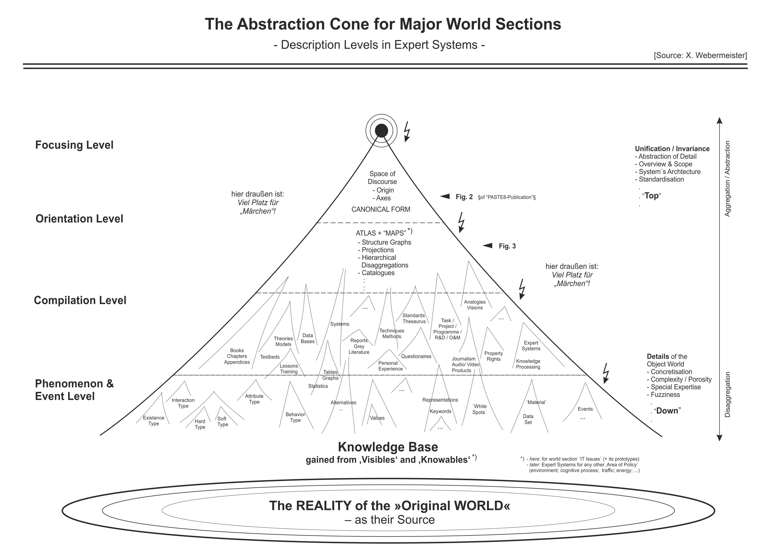
The Abstraction Cone in Fig. 1 is meant to illustrate the morphology of such an advanced descriptions:
- A lowest "phenomenon level" contains nature´s truth, unbiased by human expectations and processing: it deals with the individual occurrences, measurements and all data units, elements, primitives or detail features to be used in objective descriptions.
- Based on this, a "compilation level" assembling rules, phenomena, models, documentation and a broad variety of applications may exist.
- The descriptions and products of this compilation level can be re-classified on an "orientation level": Schemes, thesauri etc. stemming from distinct areas and perspectives can be evaluated for the degree of Necessity and Chance involved in their classification / variables / attributes in order to cluster them around common denominators.
- On a "focusing level" the top of a hierarchy of directions used in these descriptions can be established, linking all view angles and all sub-areas of knowledge to one common "focus". Or "origin".
Moving upwards in such an Abstraction Cone means progressive:
- abstraction of detail
- enlargement of scope and overview
- system's architecture issues
- standardization issues
- static and portable character (“once and for all tasks”)
- invariance of structure
- completeness in "global" coverage
- "knowledge base" character
Moving down an Abstraction Cone means progressive:
- concretization of "local" detail
- opportunity for deduction of (new) detail
- complexity and cybernetic meshing
- specialisation and work sharing
- repetitive elements ("catalogue type")
- open questions / further options
- data item and primitive character
- volatility and updating requirements
Mankind´s actual cognitive infrastructure does not comprise many expert systems with an efficiency, consistency and accuracy as advanced as the above examples. Yet, when resuming the initial zooming scenario on the same trajectory, this time however, into the opposite, i.e. microscopic direction, we will run into a few other types of Abstraction Cones:
Our knowledge on many of nature´s phenomena and laws nowadays is organized along the sequence of resolution of:
- GLOBE / geological layer / ore / crystal / atom / elementary particle
and
- Globe / ecosystem / organism / cell / gene / DNS
As a consequence of this re-organization of the available puzzle stones of knowledge into giant Abstraction Cones large amounts of scientific detail suddenly came into the range of prediction techniques. This qualitative jump, introducing deductive knowledge gathering and a wealth of consistency checks is based on relatively simple, rather formalistic and reliable scientific rules. This additional, this very efficient way of dealing with knowledge on nature's behavior, however, becomes operational only in such areas where an Abstraction Cone with a sufficiently advanced perspective has, already, been found.
This paper proposes to build another unified expert system along the relations and complexities of:
- Spaceship Earth / area of policy / macro-design / micro-design / elementary manipulations in planning
To do this, there is no need of developing all methodology from scratch. Reverse engineering as applied above can provide reliable guidelines.
Besides scaling in cartography and mathematical deduction formalisms, there are other fundamental methods of linking puzzle stones within larger Abstraction Cones. Planning Science has already developed some valuable contribution:
"Onion-Skin
Graphs" as used in Systems Analysis represent
the inside-out complement of Abstraction Cones.
When designed and exploited
according to the rules, when extended to cover all orders of magnitude involved
in the topic area treated, their outer shells (standing for top layers within Fig.1) will possess the characteristics of high
invariance as they are needed in Abstraction Cones.
(Some
illustrations of the high explanatory power of this type of perspective can be
found e.g. in [Bowen 1978].)
5. Directions Spanning "Planning Space"
The mathematical way of knowledge processing exceeds in reliability the error-prone conventional habits of thinking by orders of magnitude. Without algebraic formalism and its applications in physics, engineering or statistics, our industrial society could never have evolved.
One of the first tasks in classical algebra – preceding any deliberation on area-specific rules – is the definition of coordinate systems spanning the morphology of the space of discourse under investigation.
Usually, for economy of description and immediate linkage to the existing wealth of time-tested mathematical methods of proof and operation, orthogonal coordinate axes are aimed at from the very beginning. Orthogonal axes are independent from each other in the sense that no position on one of them can be expressed by any combination of positions on the others. The minimum cognitive investment, in terms of number of dimensions needed for gaining all ground, can be determined. This number of dimensions is invariant to the definite choice of the axes themselves. E.g. for conventional space, geometry uses Cartesian coordinates as well as Polar ones. But both systems, despite their intrinsic differences, consist of three dimensions, which are orthogonal to each other.
In such a classical area, where the "space of knowledge" is defined a priori, the coordinate system is spanned completely, once and for all. In Abstraction Cones, however, the type of detail to be described primarily depends on the layer of resolution (with many orders of magnitude to choose from). Therefore, the number of dimensions needed depends on the layer chosen.
On the ‘top’ where abstraction has already removed all fine-structure, just a few dimensions might suffice. When inverting the direction of zooming, however, additional dimensions are needed. Otherwise fine-structure, as it can be progressively discriminated from noise signals, cannot be reflected within the knowledge base. [5]
The architecture of Abstraction Cones is, therefore, linked to some priority among dimensions. Higher ranks reflect additional features of invariance.
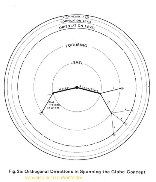
Fig. 2a, 2b and 2c try, for all three application fields illustrating this paper, to trace the first steps of this space-spanning process. They assemble the prime dimensions on which all other descriptions and all pragmatic applications seem to be founded, either explicitly or implicitly.
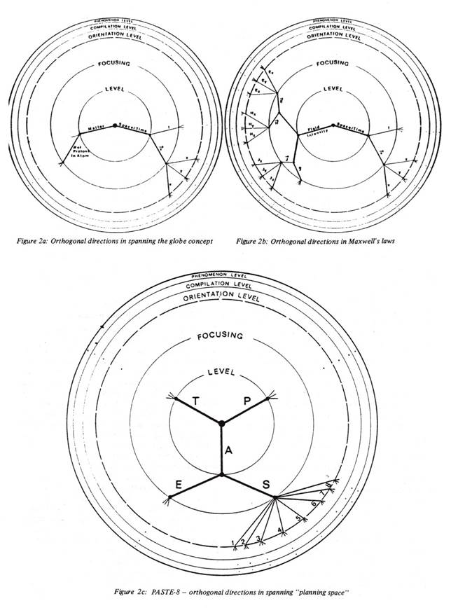
Dealing in all three cases with more than just two or three dimensions, there are unbridgeable difficulties in representing graphically that each of these directions is orthogonal to all the others. This crucial feature has, therefore, to be always kept in mind. [6]
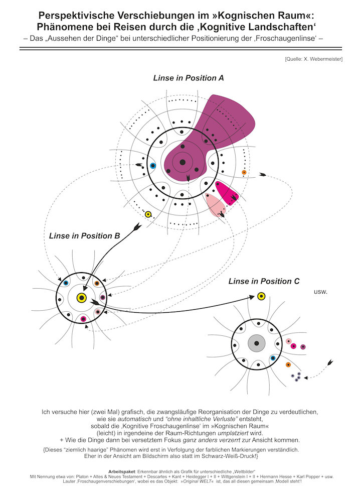
The figures, instead, concentrate on the ranking of these directions. For this purpose a "ground plan" of the abstractions cone {"Draufsicht"}, i.e. a specific perspective as seen from its uppermost ‘top’, is used in the graphs. These onion-skin representations are generated in extreme fisheye projection, a cognitive distortion which allows to accentuate the details of the upper level of abstraction.
In these figures the attempt is made to introduce each new direction on exactly that level on which it seems to be first needed in the process of top-down zooming. [7]
In the case of geography (Fig. 2a), the afore-mentioned 5 orthogonal directions reappear on the top levels. In electro-magnetism (Fig. 2b) all 14 directions are shown according to their rank. In both cases, when zooming downwards to intermediate levels, maintaining a full description might involve re-activating suitable latent dimensions. This need for stepwise increase in sophistication is indicated for each dimension by three short lines – standing e.g. for an entire hierarchy of disaggregation.
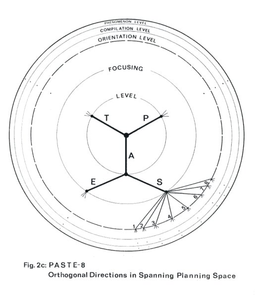
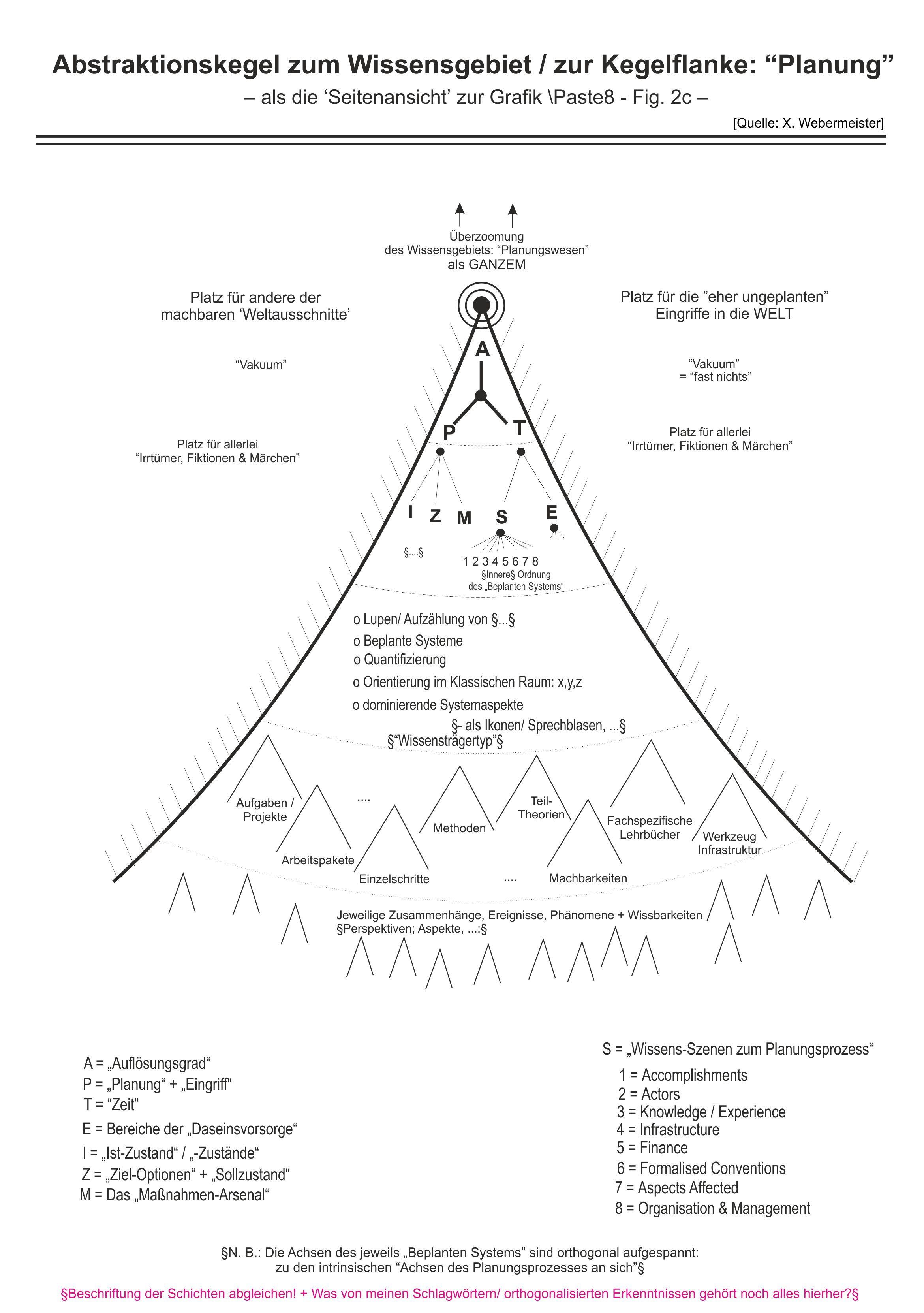
After much trial and error, a set of 12 "directions" turned out to be most appropriate for spanning the knowledge space of the envisaged unified expert system. They are shown in Fig. 2c. [8] This set (baptized PASTE-8) might initialize a description of Planning Space of similar cognitive economy as the one implemented in the reverse-engineered cases. [9]
Direction P
Represents the Planning aspect itself. It serves to
break down the space of discourse spanned by all other directions according to
the cognitive activities characteristic in making measures. It, thus,
covers "plain observation", "goal setting", "elaboration
of optional measures", "evalution", "decision making"
etc. This direction is the only one in the entire set reflecting (personal) values
and wishes. This direction when removed, e.g. by cognitive projection, a
plain non-involvement perspective is left. As it might be assumed e.g. for a "little
green men" observing the globe and the evolution on it and all goings-on with
passive curiosity. But without any intention of interfering.
–
{mittlerweile weiter aufgelöst in den Dateien: \„Planungstheorie” & Co.; \Das „Endoteleskop“-Szenario der KOGNIK; \Die Palette der ‚Elementarschritte
desPlanens‘; \...}
Direction A
Reflects the central aspect of Observation and Description
as emphasized in Fig. 1. It allows zooming up
and down Abstraction Cones for as many orders of magnitude as their (a
priori unknown) individual nature provides. Some onion-skin type methods, e.g.
"nested systems" in Planning Science, "hierarchies of
frames" or "spaces" in Artificial Intelligence have already started
to make systematic use of this most fundamental problem dimension. [10]
–
{mittlerweile stärker aufgelöst in den Dateien: \A-Kegel & Co. – vgl. insbesondere
den »Abstraktionskegel an sich« dargestellt als "Stapel
unterschiedlich stark auflösender Karten"}
Direction S Compiles 8 orthogonal, but fuzzy Scenes of Knowledge. They encompass all essential elements that drive or retard change and innovation in human society. They contain all components and processes involved in determining efficiency of measures and all indicators on which best to monitor evolution of society or to define strategic objectives. The role of each of thesescenes will be described below.
Direction T
Reflects the Time aspect, e.g. as it is needed for
spanning the phenomena of evolution, or cause-effect connected sequences of
situations as they may appear in any field of interest. Planning tasks as such included.
– {mittlerweile
stärker aufgelöst in der Datei: \Zeitflanke [11]}
Direction E
Reflects the breakdown of planning space into Sectors of Policy
or "areas of provision for human Existence". Subjects like "traffic";
"health"; "economy"; "information exchange";
"internal" and "external security" may serve as examples.
– {mittlerweile
stärker aufgelöst in der Datei: \Daseins-Bereiche}
§E: »Type of Environment«
Zwar sind grundsätzlich beliebige Environments ansteuerbar. Aber mit (wohlgewählten) "Typen" bringen wir irgendwie die natürliche Körnigkeit + Porosität des Kog-Raums mit ins Spiel.§
6. Eight Scenes of Influence in Strategic Planning
In zooming down one step
below, the "influencing factors" of direction S break
down into 8 distinct directions. The term "Scenes" is, however,
preferred in order to emphasize a difference in quality when compared e.g. to
the T-direction (which is continuous) or the P-direction
(with its discrete steps): Any of these scenes can, along the direction A,
be progressively be broken down into any degree of detail. In doing so they
will gain a rather fuzzy character, each scene itself with a lot of intrinsic
life and an evolution of its own. In further spanning planning space each scene
is, however, supposed to be – in a more general sense than with conventional
co-ordinate systems – orthogonal to all the remaining directions of PASTE-8.
– [\„Wortfelder” – als solche – \\in Auflistung; \\allerlei
an „Auflistungen“ aus dem »Unterfangen Weltpuzzle«; \...]
Fig. 3 can be envisaged as a horizontal cut near the top of Fig. 1, its central circle to be positioned one step above its petals. The petals correspond to the 8 scenes which will be explained below. For better illustration Fig. 3 contains, in its petals, already one additional step of disaggregation.
However, to do so, a specific “area of provision for human existence” was selected {for this papers purpose}. The indents for each scene, altogether reflecting the next lower layer of description, have originally been developed in the context of the area Information Technology (IT). But: The reader can verify himself that in several scenes indents named are not specific to the area of IT; they can be used in other areas of provision for human existence on dimension E as well, without any change.
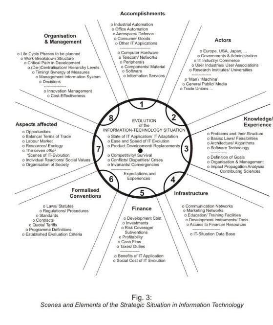
1. The Accomplishment Scene compiles the contributions which characterize a specific policy area chosen on direction E. In Information Technology it deals, therefore, with products, businesses and applications of this technology. It is the scene where e.g. opportunities for export or employment are won or lost. Files making up a more detailed scene description could be viewed as a crude Trade Information System. Higher resolving power would also be found in production statistics or lists of IT applications.
2. The Actors Scene encompasses groups and organizations occupied with or in charge of setting up cooperative, competing or independent measures. All conscious decision making for advancing or using IT is located in this scene. (But as the scene will contain at the same time leading experts and amateurs not all decisions will lead to the effects intended.) In a more disaggregated form, this scene can be described by directories, organigrammes etc. [12]
3. The Knowledge / Experience
Scene deals with the "state of the art", e.g. in
technology, methods and results of any contributing science, management or
marketing procedures etc.
By learning, an individual aims at increasing the scope of his private
excerpt of this collective knowledge. Each ‘Research & Developmen’ aims
at enhancing the overall scope and content of this scene. In disaggregated form
this scene contains all knowledge bases of existing and future expert systems, work
plans of R&D programmes, contents of scientific libraries, specs of curriculae
etc.
4. The Infrastructure Scene compiles multipurpose tools and means which usually can be accessed with no delay, by anybody, without specific efforts for contract or task planning and at minimal charge. The better the infrastructure the better the performance of the other driving forces. The present paper, essentially, aims at improving the scene of cognitive infrastructure.
5. The Finance Scene compiles the elements and procedures of the resources (made) available to the actors. Because, in decision making, impacts are most often translated into financial terms first, the crucial issues for "go" or "no-go" decisions will be concentrated in this scene. In disaggregated form this scene will contain budgets, cost structures, commitments etc.
6. The Formalized Conventions Scene embraces man-made boundary conditions which organize and regulate dispositions and behavior of the actors in any kind of role. Some of them reflect values of past problems. The lack of some others – e.g. necessary for more constructive work sharing – may turn out to be major obstacles to success. This scene is disaggregated in collections of laws, forms, tariffs, standards, taboos etc.
7. The Aspects Affected Scene takes into account the opportunities and risks of the pervasiveness of IT which allows its impacts to propagate into virtually any niche of human society. Any kind of actor might be affected. It is the range of potential impacts that ultimately defines the best clustering of areas for direction E. (It thus made "Information Technology" a suitable subject for this illustration.) This scene is to be disaggregated e.g. in terms of Technology Assessment and Impact Analysis (3).
8. The Organization & Management Scene reflects tasks and procedures in
– Finding new problems / opportunities
– Specifying goals and evaluation criteria
– Developing appropriate measures
– Exercising control
This scene may be disaggregated into issues of "planning science", handbooks on methods or alternative schemes of planning behavior.
(N. B.: “Little green men” are able to observe this scene, too, even if restricted to their no-intervention scenario. Dimension P, however, deals with active intervention; any of the scenes, number 8 included, may be the subject of such planning).
These 8 scenes – as such or disaggregated – allow for any combination with each other and / or with the remaining 4 directions in a similar way co-ordinate axes are supposed to do in spanning a Mathematical Space. They allow for the definition of pragmatic projections of planning space from virtually any other view point. They allow for defining candidates for detail perspectives for the expert system and unfolding their relationships (equivalent to "local maps"). Architects in a similar way use 3 orthogonal graphs – ground / front / side plan – from which any other view can be deduced via well defined work steps. Most planning issues do not lie within the scenes themselves but somewhere in the space spanned between some of them. They are "points" or "shapes" or "objects" within this space of discourse.
Whereas the 8 petals of Fig. 3 only describe scenes of Influence Factors, its central circle deals with issues of equilibrium among them. It, also, contains the mainstream of the evolution that results. Trends of effective development; dynamism; synergy; survival of species (here: IT-products and IT-applications); disparities; conflicts generated; etc. are subjects the central circle is to deal with.
Curious outsiders, such as future historians, will be able to best describe this open process of evolution on the basis of its own invariants, perturbation factors and long-term convergencies. They will be able to assess the scope and reliability of expectations or experience accumulated so far, at any time. They can find out whether the actual world picture provided good guidance and where it was misleading.
This specific perspective, quite remote and non-interfering, is felt to be the equivalent to the balanced positioning of the geographic origin into the center of the GLOBE. The hypothesis is that any shift of attention towards particular interests of one of the 8 Scenes would change the overall architecture of the description and reduce the cognitive economy of the conceived unified expert system. This choice of the origin and the crucial "upward" direction for abstraction being used are closely related.
– [\Das „Anlupf”-Szenario der KOGNIK; \Phänomene bei der „Verschiebung einer Froschaugenlinse“ – vor einem ‚originalseits‘ fest-stehenden Hintergrund; \...; \...]
7. Natural Laws in Planning Space – some hypotheses on PASTE-8
None of the dimensions of PASTE-8 is innovative in itself. This was not to be expected anyway. Planning in all its phases, features and variants is an integral part of our life. We have, therefore, again and again been confronted with its prime dimensions. And we permanently operate with them, explicitly or implicitly. So far nothing is new in PASTE-8; but so far nothing was new in the Geographic Abstraction Cone depicted by Fig. 2a.
The selection, however, among this over-familiar wealth of features of planning; the definition of the new Abstraction Cone in its pivotal role; the combination of some dimensions into a natural frame of reference are non-trivial tasks. The performance of a corresponding expert system in scope of validity and economy of knowledge base is extremely sensitive to the perspective chosen. These, therefore, are fundamental issues of the architecture / topology of any such system.
7.1 Time-Invariance
Hypothesis: The 8 scenes of PASTE-8 have always been and will always be a satisfactory frame of reference for the Influence Factors.
Using Information Technology (IT) again for illustration: Throughout human history, demand for information processing and exchange have always existed. Kind of an evolution has been taking place in IT, too, as it happened in any of the other areas of provision for human existence.
Initially IT didn’t even dispose of the means of speech or writing. A broad variety of signals have been used in later times. Radio waves at a certain stage allowed for a big step forward, allowed for the satisfaction of many a dormant goal. Advances in awareness and understanding of IT brought further progress. Presently, computer technology and optical fibers are again enlarging the scope of feasibilities.
But, at any time, the then available IT evolved under a mix of influence factors. For any time, – that's the hypothesis – these factors can be classified completely within the static frame of reference of PASTE-8. No modification as time goes by seems to be needed on this abstraction level, despite the tremendous progress from archaic means, to present performance and unknown future technologies.
7.2 Unification
PASTE-8 with its 8 scenes of knowledge will always turn out to be a necessary and sufficient frame of reference as long as the description is restricted to the focusing level of the resulting abstraction cone.
Hypothesis: This will be the case no matter what detail and what area of provision for human existence is chosen as starting point for a controlled zooming.
Strategic expert systems on environmental protection; transportation; health; information technology; security; etc. could, therefore, be built and / or integrated into a common superstructure.
This unification hypothesis has been tested by the author, as yet, in a few "areas of provision for human existence" (see Direction E). These tests, however, had to be been superficial, as the process of controlled abstraction over many orders of magnitude (i.e. in full analogy to visual zooming) is a tedious task and involves many unfamiliar "Himalyas" to be assessed, localized and readjusted by lateral thinking. But so far, the results look quite promising.
It is only on lower layers of disaggregation (i.e. when zooming down again according to dimension A) that sharp discrimination between different areas of application occurs.
The unification hypothesis, therefore, would claim that PASTE-8 has characteristics of a canonical form. More tests will have to be done.
7.3 Finiteness
Hypothesis: Of all the
12 dimensions used in PASTE-8 only two (A and T) are "open"
ones.
All others are finite in character.
All three geometric dimensions of the globe concept were found to be finite (and happen to have almost the same scope of 6400 km). For practical purposes the chemistry dimension, too, is finite, ending around element 92 (uranium). For the time axis, however, we, possibly, cannot specify a beginning or an end.
For the zooming dimension in geography we had no specific beginning or end either (1). The space perspective selected or any other top of an Abstraction Cone corresponds to a man-made pragmatic stop on this axis. But this does, by no means, prevent continuation of the zooming operation in attempts to unify an even larger area of knowledge. (In such a process the GLOBE and even the sun lost their uniqueness in our world picture due to similar planets and stars existing in nature.)
The hypothesis of finiteness for a scene is based on the assumption that nature is not an infinite homogeneous chaos deprived of any structure to be exploited for its description. Provided a good perspective is chosen first, with respect to both the amount of zooming and the angle of view, this structure could be confined. The hypothesis claims that this is the case for all scenes of PASTE-8 and for the dimensions P (planning) and E (the provision for human existence) as well.
A major source for misinterpretation
of this hypothesis needs immediate discussion. In geometry, when cutting a
round cone by a plane, we have learned that the result will be either a circle,
an ellipse, a parabola or a hyperbola. The first two cuts are finite in the
sense that they can completely be covered by a finite number of elements of
finite size (e.g. pieces of a jigsaw puzzle). For the parabola and hyperbola,
however, no matter how large the puzzle stones chosen are, one always needs an
infinite number. This difference in character is generated by simply cutting
the cone under different angles.
In the case of the circle, the cut has to be exactly orthogonal to the (infinite)
cental axis of the cone. Abstraction Cones have the infinite dimension A
as their building axis. Any cuts through Abstraction Cones as needed for progressive
disaggregation and final application have, therefore, to be very careful about
their "angle of cutting". The impression of infinity is easily and
unintentionally generated by involving too large a component of A
into the perspective chosen.
Perfect orthogonality of the 12 dimensions for the top of the Planning Space (and the additional orthogonality of the many dimensions to be added on its lower levels of disaggregation) is beyond our present methodological reach. If such perfection was a prerequisite for applications of PASTE-8 (and similar or derived frames of reference), all our efforts would be futile. The existence of intermediate finite stages such as ellipses instead of circles, however, provides some tolerance for insecurity and error. It allows operation with some degree of fuzziness and pragmatic trial and error.
The hypothesis of finiteness for a dimension claims that some kind of union set can be conceived where the breakdown situation resembles the features of the circle or the ellipse rather than the parabola or hyperbola. The question is, therefore, whether in each case a limited number of large puzzle stones can be found at all, which is able to cover the "scene" or "dimension" completely.
– {Jahr 2005: mittlerweile erweitert zu: \Das „Gute Fee”-Szenario der KOGNIK – „Der Vorschlag in Güte”; \...; \...}
(Even if on its surface there is no beginning or end, the GLOBE is finite in this sense. Most useful puzzle stones have been convened to be rectangular maps built on a grid derived from the geometric dimensions. They contain some quite artificial rules such as “north” being always up. And resolution scales tend to standardized values such as 1:100000, 1:10000, 1:1000 etc. – Virtually excluding any scale of e.g. 1:11256. Nor has any map in oblique perspective found wide use within Humanity's Geographical Expert System.)
In Fig. 3 an attempt has been made to give a draft break
down for one of the areas of provision for human existence (IT) by about a
factor of 10 for each of its scenes. This draft perspective seems quite
promising for finiteness in the above sense. Any imaginable issue in the IT
situation and its evolution seems to find corresponding indents (standing for
puzzle stones) to which it belongs. For further discrimination of issues, these
indents can be broken down by additional layers of description.
–
{vgl. mittlerweile: \„Platzhalterwesen”
+ „Planquadrate“ / ‚Plankegel’; \...}
Here and for drafts on the other two dimensions (P and E) more refinement may be needed before the hypothesis will be fully accepted. But, finiteness of major dimensions would be a very useful property for the architecture of the envisaged expert system. Rationalization in classical and / or computer-based knowledge processing could turn out to be quite substantial.
As long as perspectives showing such finiteness are maintained consistently in zooming down on dimension A (and despite further finite and infinite dimensions being introduced into the frame of reference during this process of stepwise sophistication), disaggregation concepts such as the one used in (3) can be applied.
It, thus, might be possible, in the long term, to completely disaggregate the ‘Abstraction Cone for the World Section of Planning’ and link layers of description over all the orders of resolution involved in as pragmatic a way as cartography does in geographic abstraction. In doing so, on lower layers, the size of the (multidimensional) puzzle stones generated would become progressively smaller. The amount of association and inference involved in using the expert system could thus progressively be reduced to a more familiar scope. In some of the "domains", even the (rather short) range of feasibility reached by today's capabilities of machine intelligence may be attained.
For the time being this
paper concentrated on the top of the ‘Abstraction Cone of Planning’.
But, zooming is a two-way process: aggregation and disaggregation; induction
and deduction; theory and application – over several orders of magnitude. The
long range goal for the unified expert system would, therefore, have shooting
and zooming in Knowledge or Planning Space done as easily and reliably as
browsing through atlases, maps, picture postcards or traveler’s reports.
The first layer to be built would be the equivalent of the GLOBE’s atlas. An atlas, by definition, covers a whole world (in set-theory language: the union set of all problem environments as seen by any perspective). It, thus, offers more scope and issues any single user would ever need to consider during a single geographical mission (or his actual planning mission). It may include several maps representing the same terrain (or issue complex) e.g. with progressive resolution for natural features (technical problems), artifacts (technologies or regulations) and available infrastructure (toolbox).
The atlas would be the
tool for overall orientation within the expert system. It comprises each and
every knowledge area. It gives rough indications on position and (cognitive) distances
of issues.
Fig. 3, by disaggregating each ‘scene’ into about
10 indents, is part of the first x10-magnification layer of such
an atlas. In Planning Space this magnification is generating 108 cells
already. Further layers of disaggregation will provide additional discrimination.
– [\„Platzhalterwesen” + „Planquadrate / ‚Plankegel’ im »Kognischen Raum«; \...]
Such a tool, quite independent of a fully-fledged expert system, could increase the precision of first-iteration problem understanding. It could save the user from neglecting vital elements of the issues involved, from ineffective (non-)work sharing, friction losses and delays in communication on his problem. At the same time the tool could serve as the top level of an access system to all intelligence of the domain envisaged. The tool would allow any new pieces of information to be understood and integrated in a fast and efficient way within the wealth of knowledge already accumulated.
Of course this tool would not be as monolithic, as geographical atlases are, where full consistency in large and small scale is guaranteed all over the globe. In a pragmatic beginning, it might rather resemble a collection of large puzzle stones where orientation and interfaces are merely "about right" – on a global level. On the local level, however, neighboring puzzle stones might not yet have been provided with unique fitting. The fuzziness option described above allows for such a proceeding.
One would not start the endeavor of such an expert system from scratch. Lots of knowledge material has been collected and pre-processed in centuries of research and development and planning. Lots of cognitive methods, conventional and advanced ones, have evolved in the historic trial and error exercise of humanity´s cultural evolution. We only seem to run into trouble whenever trying to fit them into the »World Puzzle«. With geographical knowledge, the corresponding endeavor of integration had been eased tremendously once the GLOBE concept had been found. All material collected before could be scanned again under its new perspective. Sorting out previous misunderstandings, misleading assumptions, inconsistencies between neighboring puzzle stones and detecting overall gaps in knowledge, however, took quite some time and resources. And, in the Middle Ages, this re-adjustment created quite some unrest for philosophy and politics. But, atlases – these eminently useful and everlasting structures in humanity´s geographical expert system – emerged and were soon disseminated as tools. Only when based on a consensus making clear which concepts are fundamental reflections of nature´s behavior and which concepts are artificial (to ease a pragmatic description) can the benefits be fully exploited: Unbiased "complexity crunching" in modular architecture; standardized steps of resolution of detail, e.g. providing for overlay technique; early warning on "white spots" in the knowledge base; "structured planning", a top-down design strategy defined along the same experience which lead software technology to emphasize structured programming; a consistent breakdown of goals into lower-layer criteria might be made use of.
Possibilities for systematic proof and backwards calculation have provided classical mathematics with its superior reliability. Comparing issue descriptions on connected layers of resolution might introduce similar possibilities for proof and control. But to do this we need consistent frames of reference.
– [\all die ‚Rütteltests im Kognischen Raum‘; \...; \...]
From
a local perspective
(e.g. by "swimming" deep in the earth´s magma), it would be very difficult
to find the center of the globe and, therefore, a fundamental origin for the
coordinate system. There is no easy signal supporting orientation in such local
search. From the far-off "space perspective", however, when the
earth's outline is fully visible, its very center is pinpointed with no effort,
risk or doubt.
Correspondingly, any planning perspective of "local" character might
lack some of the most important signals. Views from much larger distance must
be analyzed for any hints on similar "outlines" first.
All this indicates that high-scale work on the Top of the Abstraction Cone – as a "once and for all" task for the scientific community – should come first in designing and solving this big puzzle. Again there are some grave risks of misunderstanding. Reverse engineering may help again. It teaches us that in real, pragmatic expert systems, dimensions quite different from the ones quoted in previous chapters will eventually have to be applied:
1. The canonical dimensions in Fig.2 do not dominate all tools:
- Four different textbooks, when checked for Maxwell's laws, four different formulations were found. But, even if the formulations were so different from each other that only physicists could recognize without the textbook's explicit help that they were, indeed, dealing with one and the same laws, each version ultimately was based on the 14 orthogonal dimensions connected as in Fig. 2b.
- The breakdown process in the examples of Fig. 2 will, as indicated, have to be complemented on lower layers by additional dimensions. For spanning any perspective treatable by the methods of statistics, the dimension of "multiplicity / repetition" will have to be first introduced in appropriate positions. Other dimensions, as powerful in their explanation capabilities, will have to be integrated, too, as soon as knowledge on lower layers is aimed at.
- In geographical maps one of the three geometric dimensions, usually, is completely neglected. Its only trace can sometimes be found hidden in contour lines given. Then “height” is measured from some "Normal Zero". No longer from the GLOBE’s center.
Whenever there are reasons for modification as good as in these examples, similar freedom of presentation would have to be accepted in a PASTE-8 context, too.
2. In geography, progress has meant that all spots of interests and all large sized puzzle stones have already been investigated, documented and published. No major "white spots" remain on the GLOBE’s map. However, in our geographic expert system, we are still far from knowing all that can be learned or might be of interest. E.g. deposits of oil, gold or other resources continue to be the object of searches in our times, too. [13] Even if theoretically feasible, definitely not all "local" details, e.g. all bricks in each house, are recorded in their exact position within the overall frame of reference.
3. The expert system may be refering to any other Abstraction Cones or subcones. At appropriate positions, reference will have to be made from Planning to e.g. Geography; Atomic Theory; Biology; Meteorology; Etology; etc. Their own inherited models are to be linked on the orientation and compilation levels. Pursuing the goal of unification would mean reducing the number of separate Abstraction Cones needed to the strict minimum. The remaining ones would have to be connected by those dimensions which they all happen to have in common.
4. There is no need or sense to always have problem solving pass via the Top of the Abstraction Cone. When looking for some address, tools like telephone directories or taxi drivers (as local expert systems) are obviously more useful than the unified space perspective. Specialized tools of such kind will have to form integral parts of the overall expert system.
5. In world matters we would not trust a guide who is asserting the “Himalayas” to be a lake in Indonesia or Berlin to lie on the equator. On the other hand we easily accept that e.g. the line width as given on maps for simple highways in reality would correspond to road cross sections which would cope for tens of parallel lanes. In the planning area we are still far from a stage of consistency of assumptions. A consensus on acceptable perfection and imperfection is still to be achieved or convened according to situations.
Man can´t escape living on the GLOBE. He can´t escape living within the restrictions expressed in Maxwell´s laws. And he can´t escape living permanently in a planning context. But, in each case, he can try to adapt the scope and perspective of the cognitive descriptions he relies on most to the specific dimensions as they are given by the nature of the subject itself.
Today, no one would seriously ask humanity to abolish the geographical expert system in the way it is built up on the GLOBE concept. There is no pragmatic alternative. Nor would anyone – e.g. under the claim for more cognitive freedom – seriously ask to forget about Maxwell´s laws and physic´s mathematical deduction techniques involved in their application. A concept like the ‘Abstraction Cone of PASTE-8’ might, therefore, be worth some effort of research and development, too. An overall unified expert system and a progressive synthesis of methodologies could emerge.
The frame of reference
for this additional expert system has been described; an interdisciplinary toolbox
of methods is waiting for assessment and application; a wealth of dormant material
has been accumulated by mankind through the centuries in many complementary
areas and sciences; additional reverse engineering on classical expert systems
can provide further guidance, whenever needed.
Compromising in response to missing knowledge cannot be avoided, but can be
managed. User-bound constraints, e.g. due to limited cognitive channel widths
will reduce the architectural options in number. Resources will be limited,
thus not allowing the building of all layers and areas of the expert system in
parallel. Priorities will, therefore, have to be set.
Why is the concept of PASTE-8 first presented to the Planning-Science Community instead of e.g. the mathematical, the philosophical or the artificial-intelligence community? Next to the direction A, the aspect of planning, i.e. the direction P of PASTE-8, plays the paramount role in this concept. Planning community, by thorough introspection, would, therefore, have to play the leading part in such developments. And as ‘planning’ is the dominant application for expert-system services, anyway, it would not only be a major contributo, but also its prime user.
{The thread of reasoning of this paper has, already, been presented in September 1984 at the Annual Meeting of the Deutsche Gesellschaft für Operations Research (DGOR) in St. Gallen, Switzerland.}
*****
References:
(1) Morrison, P. et al.: “Powers of Ten”,
Scientific American Books, W. H. Freeman,
San Francisco 1982
(2) Bowen, K. C.: “Research Games: An Approach
to the Study of the Decision Process”
Taylor & Francis, London 1978
(3) Liebermeister, U.: “Universal Checklists
in the Concept of ‘Impact Trees’”, in: Burkhardt, D. F., Ittelson, W.
H.: “Environmental Assessment of Socio-Economic Systems”,
New York 1978, p. 133 – 158.
*****
zur „Diskursraum-Aufspannung im Schema PASTE-8“
·
Vergleiche hierzu
das »Puzzle WELT« mit seiner ‚raumgreifenden’ Erweiterung des oben zur Debatte gestellten
‚Diskursraums’! ...
– [\Das
»Unterfangen Weltpuzzle« – immens als GANZES; \zum ‚Raumgreifungswesen‘
– \Prinzipgrafik
dazu – in Seitenansicht + in Draufsicht; \„Diskurs- + LEGE-Räume“ – als ‚Wissensträger‘ + \deren jeweilige ‚Aufspannung‘ +
‚Unifizierung‘;
\‚Achserei‘-Arbeit
– als solche; \Prinzipgrafik: „Phänomene“ bei der Verschiebung eines ‚Froschaugenlinse‘
vor einem originalseits fest-gehaltenem „Hintergrund“ – in Draufsichten; \Definitionsgrafik: Der „Ausgezeichnete Blickpunkt“ – in Seitenansicht; \...
--- \Der LEGE-Raum zum »Puzzle WELT« + \Grafik-Entwurf dazu – in zentrierter
Draufsicht für den »Privilegierten Beobachter« ‚schalenweise ausgerollt‘;
\...]
·
Arbeits-Paket: Weitere ähnlich orthogonalisierende Systemische
Grafiken …
– [\Der
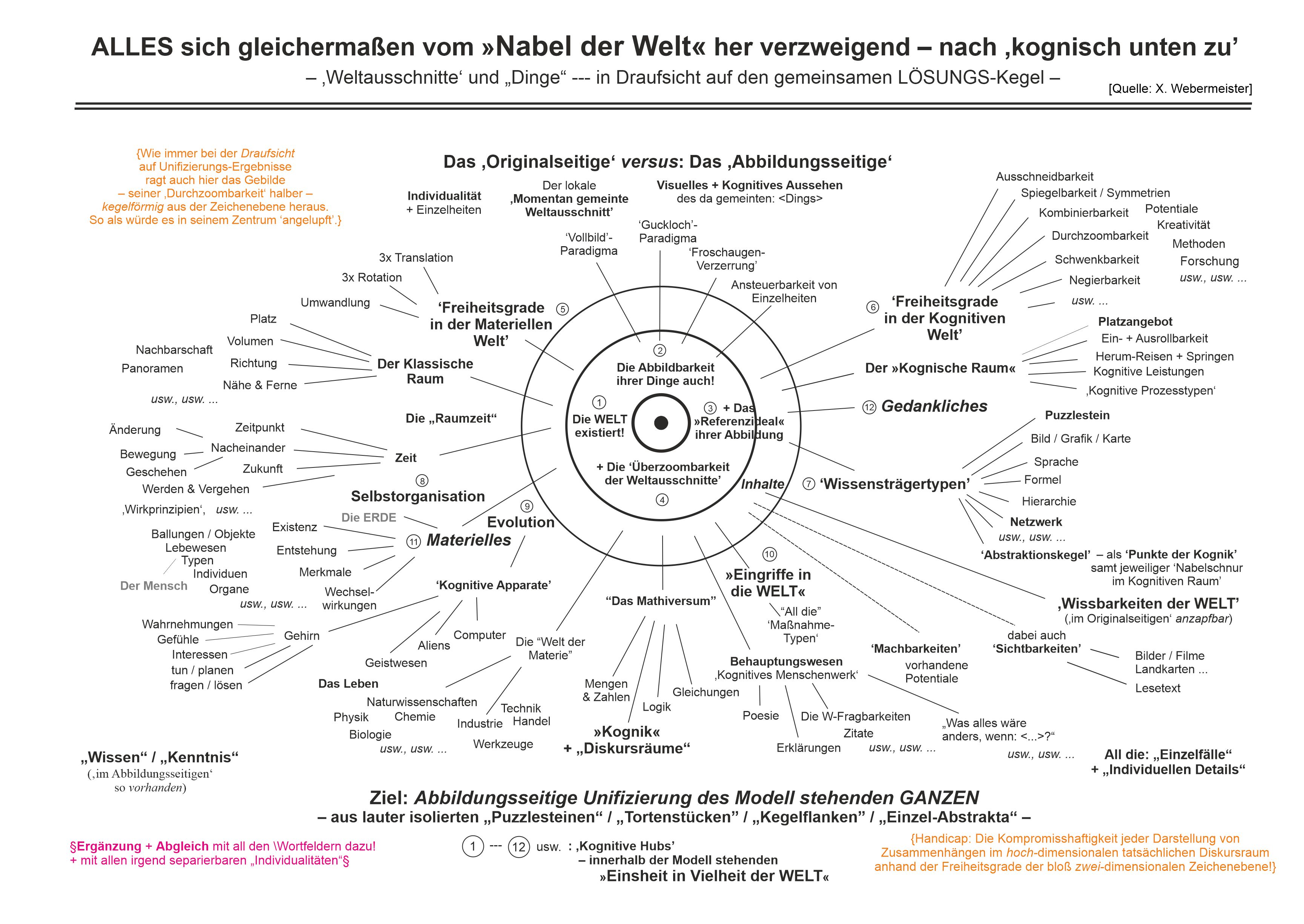
‚Nabel der Welt‘ – in seiner Draufsicht; \...; \...]
·
...
–
[\...; \...]